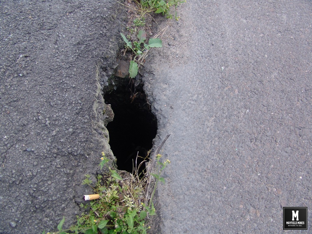
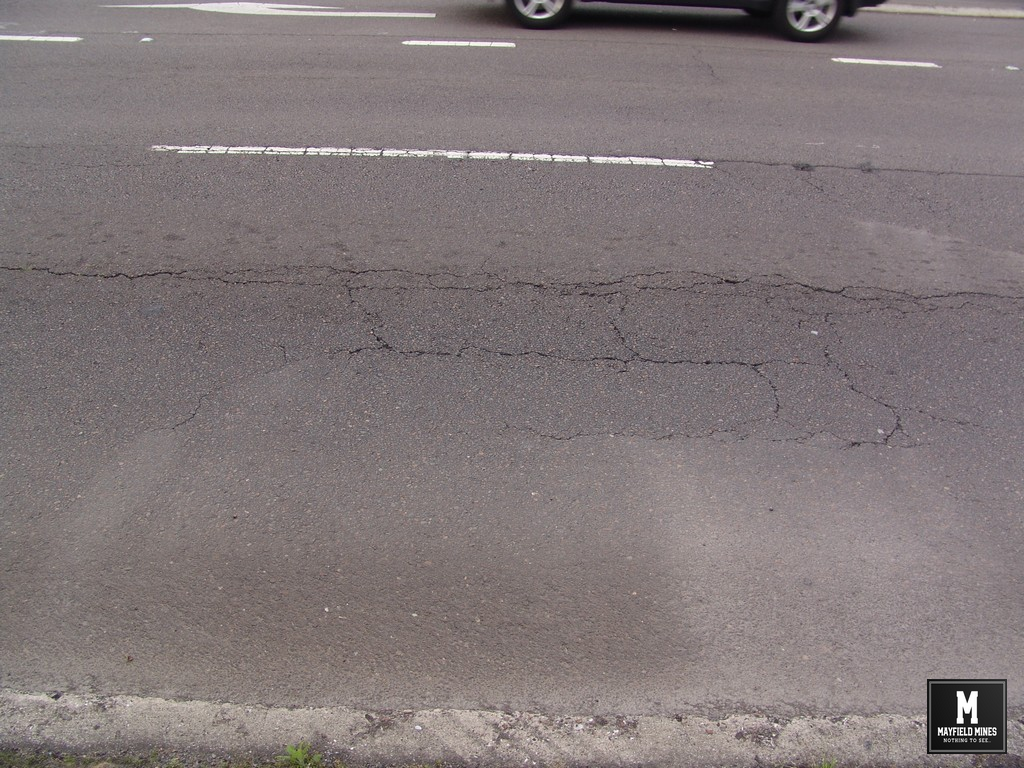
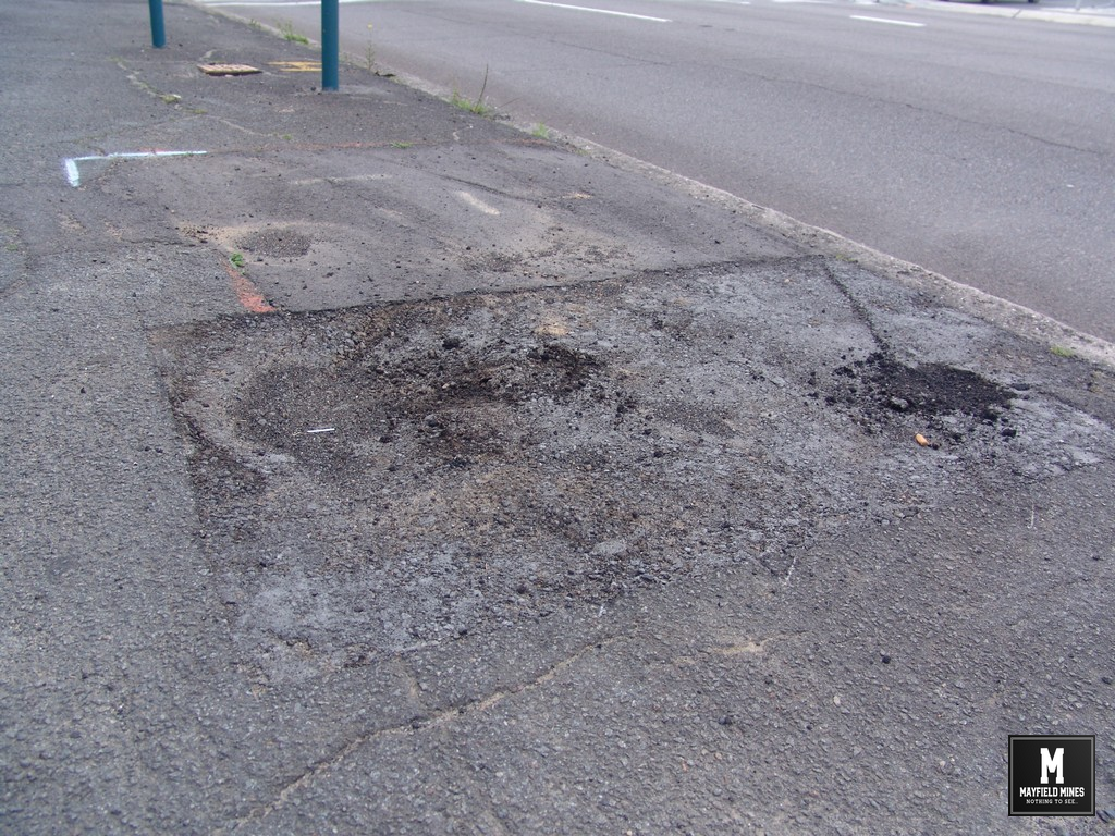
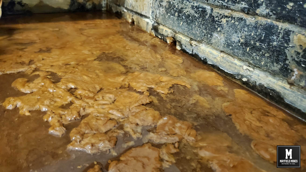
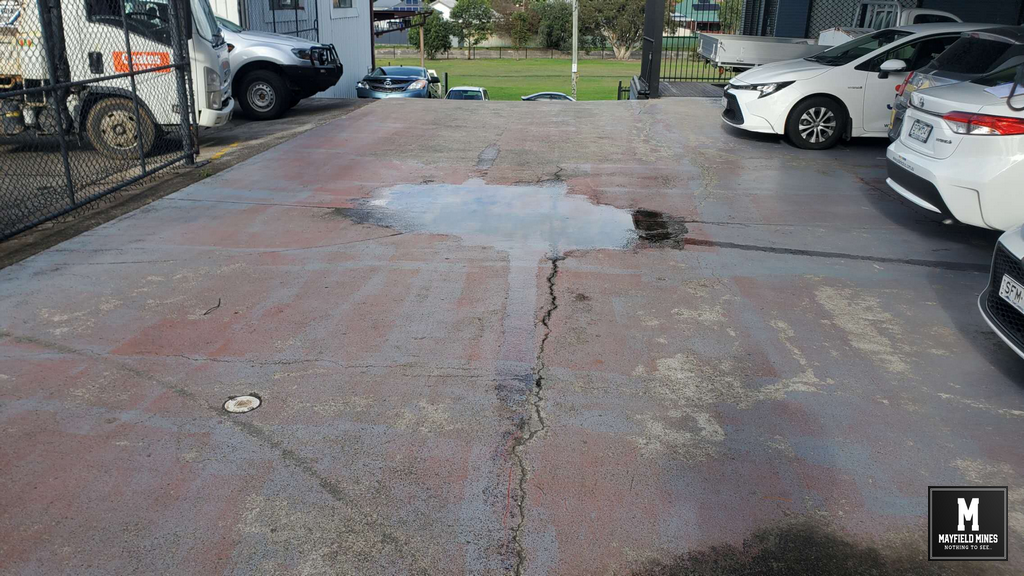
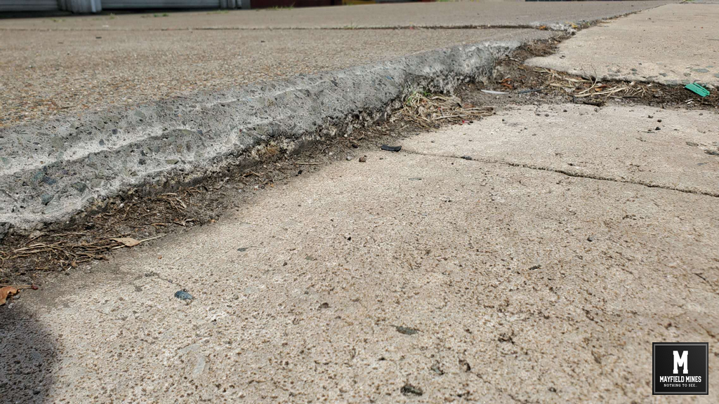
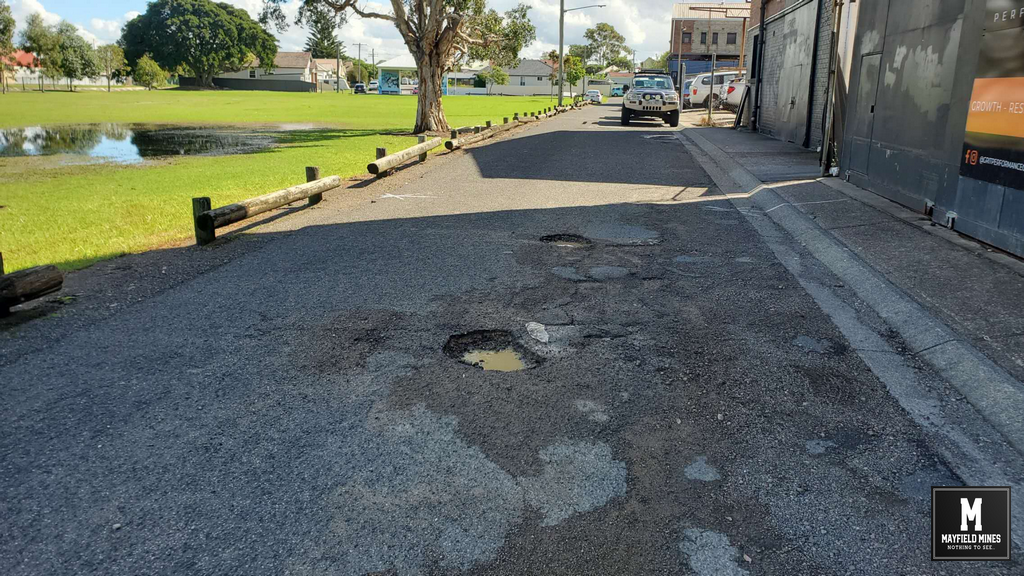
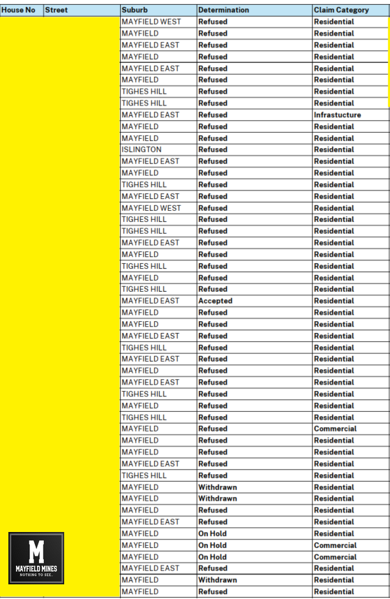
Mayfield Mines

A Mine Subsidence and Flooding Problem in Newcastle

  • News
  • About Us
  • Support Us
    • Join Our Team
  • Contact Us

Legacy Mines NSW Not Responsible for Mine Water Flooding?

June 9, 2025

We contact Legacy Mines on 16th October 2019, and asked for help but we are ignored. In December 2019, mine water has found its way to the ground floor of 44 Maitland Road flooding the entire floor and closing our office. Its been two months waiting for Legacy Mines to make a site inspection, they are not coming.

After the flooding of our office, we again contacted Legacy Mines and talked with Nick Staheyeff (Manager Legacy Mines, Department of Planning) who informs us that he does not believe our problem is within their charter.

So who is responsible for mine water coming out of abandoned mines and flooding properties?

It seems no one.

Mine Water Office

Mine Water Office


Filed Under: Legacy Mines NSW, Mine Subsidency Advisory NSW, Uncategorized

Not Mine Subsidence Related – it’s a Legacy Mines Problem according to SA NSW

April 12, 2025

In Oct 2019, we called Subsidence Advisory NSW to visit our premises.

They visit promptly and treat their inspection as a “Safety & Remediation Report” asking us to work with Legacy Mines department handing us the Legacy Mines brochure and contact number. Later, Subsidence Advisory NSW refused our claim suggesting;

• There are no mines under 38 Maitland Road Mayfield
• Mining terminates under Maitland Road
• The nearest Colliery is Brough Hall and Griffiths
• No damage to the building consistent with mine subsidence was observed or reported.

Note: David Sedgman was the SA NSW representative who acknowledged mine workings with our buyer during the 2015 sales negotiations. He is the same person who visited us in 2019 stating that there are no mine workings under the same property.


—————
2002, Mines under our building as discussed with engineer (GIPA)
2012, No mines under our buildings as told to us by SA NSW
2015, No mines under our buildings as told to us by SA NSW
2015, Mines under our building as per David Sedgman SA NSW (GIPA)
2016, Mines under our buildings as per Ian Bullen SA NSW (GIPA)
2019, No mines under our buildings as told to us by David Sedgman/Paul Lambert SA NSW


Subsidence Advisory NSW Property Not Undermined

Subsidence Advisory NSW Property Not Undermined

Filed Under: Mine Subsidency Advisory NSW

Subsidence Advisory NSW Acknowledge Mine Workings Privately

April 11, 2025

38 Maitland Road was abandoned by us in 2014 due to subsidence issues and flooding. We tried to get support from a variety of government agencies including Subsidence Advisory (Mine Subsidence Board), Newcastle City Council, Hunter Water, and more… All could not explain why the buildings were cracking and why we had water flowing into the buildings.

In 2015, we try to sell 38 Maitland Road Mayfield, and allow a developer to handle their own investigation where they hired independent geotechnical engineers. These included RCA Australia, Northrop Engineers and Cardno (Stantec).

As part of the analysis, the Cardno/RCA conducted lengthy geotechnical investigations including borehole testing and concluded that it is most likely the borehole coal seam and mine workings are approximately 7m below EGL from the building at the front of the site. An updated mine workings map was created and shared with SA NSW.

In 2015, David Sedgman (acting District Manager) from SA NSW is discussing the development application with our 3rd party buyer. His first paragraph to the proposed buyer is;

ENQUIRY NO: TENQ15-13682N1
LOT 1 DP 782225 SEC NO 38 MAITLAND RD MAYFIELD

This property is located within a proclaimed Mine Subsidence District. The purpose of a District is to prevent damage through surface development controls that take account of the risk of damage by subsidence from old, current and future mining.

In Feb 2016, Ian Bullen (District Manager) from SA NSW continues discussions with the 3rd party buyer;

“I have had a look at the geotechnical report as well as Northrop Engineers comments, the use of bored piers would need to be assessed on merit when you submit your DA drawings, it will be the decision of the Board as to weather they believe that bored piers will address the issues with shallow mining and the long term stability of the structure.”

“Due to the extremely shallow depth of the workings the Board would not be able to confirm or comment that the workings will or will not collapse causing damage to the infrastructure and or injury to the public. This is something that your Geotechnical consultant would need to comment on, if the Geotechnical consultant believes the risk is high then they need to specify a suitable method such as grouting to make the workings safe.”

Note:     Ian Bullen was the SA NSW representative that met with us on site in 2012 and 2015 stating that there were no mine workings on our properties.

After a long process, the developer walked away from the property, remediation costs with the ongoing water problem making this property unmanageable.

—————

2002, Mines under our building as discussed with engineer (GIPA)
2012, No mines under our buildings as told to us by SA NSW
2015, No mines under our buildings as told to us by SA NSW
2015, Mines under our building as per David Sedgman SA NSW (GIPA)
2016, Mines under our buildings as per Ian Bullen SA NSW (GIPA)


Subsidence Advisory NSW Acknowledging Mine Workings under 38 Maitland Road

Subsidence Advisory NSW Acknowledging Mine Workings under 38 Maitland Road


2015 Mine Water Flooding 38 Maitland Road

2015 Mine Water Flooding 38 Maitland Road

Filed Under: Mine Subsidency Advisory NSW, NSW Government

Subsidence Advisory NSW The Art of Doing Nothing (whilst looking like doing something)

April 10, 2025

I believe corruption starts here all will be explained in upcoming posts.

In 2012 and 2015, SA NSW visited our 38 and 42 Maitland Road Mayfield premises. During the visits, they suggested there were no mines under our buildings.

Maitland Road had subsided and there was a sinkhole in the kerb (Newcastle City Council informed everyone that the hole was because of an old 1968 telegraph pole stump which was eaten by termites, creating the 3m wide crater), SA NSW suggested that the problems may be caused by old mine workings under Tarin Street.

There is subsidence in opposite streets, subsidence on Maitland Road, sinkhole in the kerb, subsidence in our buildings and brown water flowing into our lower warehouse. With all of this, no one can tell us anything, other than its not related to them.

With no solution, its time to sell.

——————-

2002, Mines under our building as discussed with independent engineer (GIPA)
2012, No mines under our buildings as told to us by SA NSW
2015, No mines under our buildings as told to us by SA NSW


2012 Maitland Road Sinkhole

2012 Maitland Road Sinkhole


2012 Maitland Road Subsidence Evidence after previous repair

2012 Maitland Road Subsidence Evidence after previous repair


2012 38 Maitland Road Ground Floor

2012 38 Maitland Road Ground Floor


Filed Under: Mine Subsidency Advisory NSW, NSW Government

NSW Government Coverup

April 9, 2025

As more and more information is becoming available, its very evident that the NSW Government Coverup has been well in place for a number of years. After been told there were no mine workings beneath our properties for over 13 years, independent/government evidence on hand shows that the government has been aware of the mine network and has purposely withheld this information, in what we can only assume, to speed up as much financial losses that we bankrupt.

Every building has honeycombing cracking and subsidence, every building has water damage due to mine water, 38 Maitland Road has been derelict since 2014, our office has been flooded since 2019….sinkholes along Maitland Road kerb, subsidence on the footpath, and subsidence cracking throughout Maitland Road was still not enough for NSW Government to acknowledge underground mine networks.

We were waiting for both legal advice, and, waiting for GIPA (freedom of information) documents. Let’s just say the NSW government has made it so difficult to get any information. After waiting six months to receive documents, we found a lot of information was still being withheld.

People have come forward, evidence has been found, corruption has been exposed. I believe deceit, corruption and wilful delaying tactics have been used in order to coverup the truth about abandoned mining in Mayfield. Everything will be exposed.

What mine….oh that one.


Mine Map Maitland Road Mayfield

Mine Map Maitland Road Mayfield in 2002

Filed Under: Mine Subsidency Advisory NSW, NSW Government

Mine Subsidence Maitland Road Mayfield (1884)

December 11, 2024

Mine Subsidence Maitland Road Mayfield (1884)

Two years before the entire mine network was abandoned (in 1886), parts of Maitland Road were closed due to mine subsidence.

Below is an extract from historical newspaper and government reports;

Mr J McKenzie, inspector of the coalfields, has made a report by telegram and letter, to the Minister for Mines in reference to the undermining of the Maitland Road.

“On arriving at Peppertown yesterday I found another pitfall had taken place on AA Co or southern side of Great Northern road caused by Spennymoor side taking away the coal adjacent to the road..

I went down the Spennymoor Company’s pit, at Peppertown, with Mr Inspector Dixon today, and examined the roof of 10 4×5 yard bores which some time since were driven across the road by the Ferndale Coal company, and also made a careful examination of the workings up to where the recent pitfalls had taken place, through the Spennymoor company having worked out the coal under some portion of the footpath on the southern side of Maitland Road”.

  • Peppertown = Mayfield East
  • Spennymoor = Colliery between Maitland Road and Litchfield Park
  • Ferndale = major colliery in Tighes Hill and Mayfield East
  • Spennymoor Colliery & Ferndale Colliery were joined by mining under Maitland Road.

140 years later, mine subsidence continues in the same locations. However government departments are still saying that there are no mines under us, or, “unsure” if mining occurred.

There is no confusion – thanks to historical Newspaper and government records, it explains well why subsidence continues and repeats in the same locations.

Maitland Road Subsidence

Maitland Road Footpath Subsidence

Maitland Road Footpath Subsidence

Sinkhole 2012 Maitland Road Mayfield

Sinkhole 2012 Maitland Road Mayfield

38 Maitland Road Subsidence 2012 (after repair)

38 Maitland Road Subsidence 2012 (after repair)

38 Maitland Road Subsidence Footpath

38 Maitland Road Subsidence Footpath

Filed Under: Mine Subsidency Advisory NSW, NSW Government

Mines in Mayfield – Yes

December 9, 2024

Mines in Mayfield…yes.

We still have people telling us that there was never mining in Mayfield. Whilst the mine network was dominated by Ferndale Colliery there was up to twenty smaller collieries mining in the Mayfield and Tighes Hill region. Below is a short extract from reports at the time.

“….spirited rivalry or competition seems to have existed among the conterminous small collieries as to which could work the greatest area of coal from under this important thoroughfare.

No restrictions seem to have been imposed on the workers. In consequence, this road has been honeycombed with workings for a considerable distance, and is at present supported by pillars so thin as to be almost invisible.

It is alleged by the owners of Ferndale that they left a sufficient barrier of solid coal around each of the small collieries shown on plan, No. 1 Appendix, but that this barrier, as well as the top-coal, and as many of the pillars as could be got at, were removed by these small owners; and in this manner – and by reason of their own thoughtless cupidity – the twenty small collieries, or thereabout, on this ridge have been communicated with each other. As a result of these inter-communications, when Ferndale was inundated the whole of these collieries were filled with water.”

We understand that a number of government agencies are following Mayfield Mines – for your reference, mining did occur in Mayfield.

Here is the link for the Royal Commission on Collieries Report (Ferndale Colliery) 1886.


Royal Commission Ferndale Mine 1886

Royal Commission Ferndale Mine 1886

Filed Under: Legacy Mines NSW, Mine Subsidency Advisory NSW

What has been happening over these last 12months with Mine Subsidence in Mayfield?

October 29, 2024

What has been happening over these last 12 months?
More subsidence, more mine water flooding, but no action from government agencies. In these photos;
– footpath subsidence in front of Thompson mechanics is now at ridiculous level
– Litchfield Park has been flooded most months
– Myola Street is peppered with potholes
– new subsidence in all buildings
– ongoing mine water with crazy humidity levels
44 Maitland Road Meeting Room 241029

44 Maitland Road Meeting Room 241029


38 Maitland Road 241029 - More Cracks

38 Maitland Road 241029 – More Cracks

Maitland Road Footpath Thompson

Maitland Road Footpath Thompson


Myola Street Potholes and Litchfield Partk Flooding

Myola Street Potholes and Litchfield Partk Flooding

Filed Under: Mine Subsidency Advisory NSW, NSW Government

Subsidence Advisory NSW Withholding Information – Just the Facts

October 23, 2024

“Subsidence Advisory NSW is the NSW Government agency responsible for supporting property owners living in areas where subsidence from underground coal mining may occur.”

Since our last posts 12 months ago, new information has emerged that Subsidence Authority NSW has purposely withheld information from us.

Just the facts;

  • In 1886, a network of mine workings were interconnected, flooded and abandoned in our region. This land was then sold to the public, with services built over the abandoned mine network.
  • Over 15 years ago, water and subsidence damage started occurring in our property, later spreading to other properties.
  • Subsidence Advisory informed us that there are no mines underneath our property. Government agencies are using this information.
  • Our subsidence and mine water flooding has been allocated as a Legacy Mines problem. Over these years, various agencies believe water from stormwater and Hunter Water assets are finding their way into our properties.
  • During a Legacy Mines Report in 2020 (commissioned by the NSW Deputy Premier), via Freedom of Information documents, we found that Subsidence Authority withheld mine map information resulting in the consultants to use 1886 mine map data and not the most recent geo-referenced mine maps.
  • In March 2023, we requested Subsidence Authority to meet with us as there is conflicting information. After being delayed for months, we were told we needed to lodge new mine subsidence claims. These were lodged in June 2023.
  • Due to ongoing lack of support from Subsidence Authority, in May 2023 we applied for mine maps beneath our property via the NSW Resource Regulator. In August 2024, we received these maps which show multiple abandoned mine workings beneath our buildings. We understand that Subsidence Authority delayed the release of these maps.
  • In order to receive these geo-referenced mine maps, we needed to sign a non disclosure agreement that last for 50 years. Therefore we cannot show you the full extent of the evidence.
  • These current geo-reference street mine maps show a network of abandoned mines that are interconnected, from Mounter Street to under our buildings. The maps show direct correlation between subsidence and mine water flooding in our buildings and neighbouring streets.
  • Since the lodgement of the June 2023 subsidence claims – Subsidence Authority has avoided sharing information, visiting the sites, or meeting with us.

Is the NSW government through its agencies, taking all steps possible to hide the truth and bankrupt us?


Subsidence Authority Mayfield Claims

Subsidence Authority Mayfield Region Claim Outcomes

Filed Under: Legacy Mines NSW, Mine Subsidency Advisory NSW, NSW Government

Legacy Mine Maps for Mayfield Have Been Received

September 5, 2024

After 15 months of lobbying the NSW government, we have finally received the geo-referenced abandoned “legacy” mine maps. We now have direct correlation between the location of the abandoned mine network with over 100 instances of subsidence damage in our properties.

Water flowing “randomly” from under the footpath and into our properties (and others along the street) can be directly connected to the abandoned mines. In these 15 months, 25,000,000 litres have flowed through our properties. The water has permanently flooded Litchfield Park as well as other property owners.

Subsidence and sink holes around Maitland Road now can be fully attributed to the old mine workings. These sink holes have been previously “signed off” by Newcastle Council being caused by termites eating a 1968 telegraph pole. Even though the holes have moved up and down the street, Newcastle Council still maintain its termites causing the troubles. Oh, and they continue to handle street subsidence and sinkhole repairs.

It’s time for property owners in Newcastle to be able to obtain current geo-referenced mine maps on their own property, not a foggy “zone of influence” statement. For more than a decade, Subsidence Advisory has withheld information from us. Even though NSW Government agencies have acknowledged our problems, and understand that our properties/businesses have been destroyed, they have continued to keep silent.

We have collected extensive information in Tighes Hill, Mayfield, Carrington and other suburbs in Newcastle thanks to the support of local home and business owners. Shortly we will start a public campaign and hope you can work with us to bring changes to the way old mine workings are handled in Newcastle and NSW.

38 Maitland Road Subsidence Damage Repair

38 Maitland Road Subsidence Damage Repair


mine water 38 Maitland Road Mayfield Carpark

mine water 38 Maitland Road Mayfield Carpark


Maitland Road Mine Subsidence Damage 04

Maitland Road Mine Subsidence Damage

Filed Under: Legacy Mines NSW, Mine Subsidency Advisory NSW

  • 1
  • 2
  • 3
  • Next Page »

Copyright © 2025